Growing up in
Illinois in the 1960's, I only knew of Two Counties. Those were Will and Cook. I
lived in Will County. Cook County was the more 'significant' county to the north since this is where Metropolitan
Chicago and it's major suburbs are located. Will is to the south and
southwest of Cook. Back at that time Will was much more rural than Cook although a bit of the southern Chicago suburbs overlapped into Will.
Because our home was south of the border, in Will County, we were located at the extreme northwestern corner of the Crete-Monee School District. So, during my high school years, I took a six mile bus ride each
morning to get to school in Crete. After school let out, I took another bus ride home in the afternoon or evening, (In the evening I would take the late bus for the kids who stayed late at school for athletics.) With stops to discharge my fellow students, the ride generally took about 40 minutes
in each direction. Being at the extreme end of the bus route, I was one of the first students on in the morning and last off in the evening. Lucky me.Anyway, other than this
main fact about where I was going to go to be going to high school, the idea of
counties or other civil borders did not enter my mind. I was young
and oblivious. My mind was busy with other things.
Many people are thru their lifetimes preoccupied with family, school, career, sports and other entertainment as well as having other priorities; as a result they may never give the area where they live much thought. Sort of like fish living in water. It's just there. For myself, I have gradually taken an growing interest. But it has taken a long time and a number of insights to gain a deep appreciation for the geography and history of a place.
My youthful ignorance
of the nature of counties as political or geographical entities continued until I was attending
Agricultural College at Iowa State University in Ames in the 1970s. One of the classes I
took during my senior year in 1975 was Farm Appraisal.
This class was an
eye-opener for me. I learned about how farm properties were laid out on the landscape and
how to understand the legal descriptions that ended up in the Deeds and Titles
(and loan documents) associated with farms.
When you fly over
much of the United States, looking down from 30,000+ feet, you see
what looks like a quilt-work of squares. These are not natural but man-made and mostly represent property lines. The
squares you see are usually called "Sections". These sections measure a mile on each side.
(see aerial photo above). Each Section is a Square Mile and made up of
640 acres. In my appraisal class I also learned that Sections are part of a "Township" which, in turn, is a subdivision of a County. Counties are typically rectangular but they can have various shapes. Sometimes their boundaries may be a river or large body of water. Townships are almost always a square and typically made up of 36 Sections, The standard township is six miles long on a side. (see diagram below) So a
Township typically has around 23,000 acres (36 sections x 640 acres)! Occasionally a township may vary from being a square because of a body of water or for historical reasons. But 99% of the time, it's a square.
 |
| 36 Sections in a Township |
As one of the
exercises in the Farm Appraisal Class, I had to formally go over a particular farm
(I was able to use a 520 acre farm owned by a girlfriend's parents in Northwest Iowa). I studied the soil
maps for the farm, walked the ground, estimated crop yields, compared her parent's farm to
other similar ones that had been recently sold in the county. From this collection of information I was able to arrive at an estimated market value. I followed standard methodology as laid out in the course and got an A for my efforts. Nice. But more than a good grade, I gained the beginning of an appreciation for the unique character of a particular patch of this planet earth. It was not just as an economic entity but something more.
The course in Farm
Appraisal was my introduction to looking a piece of land as a
specific place. In the years and decades that followed, I gradually, practically learned more about rural geography.
 |
Young Dairy Fieldman
|
In my mid 20s, I
came to St. Croix County, here in Western Wisconsin. For the first six
years that I lived in the county, I worked for a Dairy Cooperative, Mid-American Dairymen, and spent each day visiting farms. My job title was “Dairy Plant
Fieldman” and my duties required me keep in
touch with the member farmers and help them with quality control issues, and much more. I was given a company vehicle and a plat book. (A plat book is a series of township maps that show the ownership of each farm.) 
During the years that I worked for the Co-op, I would drive
from farm to farm, inspecting the dairy barns, checking to make sure that
milk was produced in a sanitary manner. I would walk thru the barns and the milk house and inspect the milk-handling equipment I had a flashlight to look inside pipelines. I had a pocket thermometer to check the temperature of milk in the bulk tank. Often I'd go out into the fields, pastures and meadows to find
and have conversations with the farmer. He might be doing spring plowing. Or perhaps he and the family were baling hay in the summer. Or harvesting corn in the autumn. With my background, I knew what it was like to milk cows and do the various farm chores. This helped me build a report with the farm families. Some of these families have become life-long friends who I still know today. I've seen generations born as well as pass away. I feel very fortunate to have seen and participated in this community.
Being a Fieldman was a year-round outdoor, hands-on job and so
sometimes I was out on the roads in frigid and snowy conditions. Besides the weather, I also dealt with mud, cow manure, and bugs. But for much of
the year, it was an idyllic sort of job, where I could enjoy nature,
beautiful landscapes, fresh air and the variability of seasons. But the more practical aspect of the job was learning to navigate the county highways and township roads so that I could locate all the farms that I was required to visit.
 |
| St Croix County and It's Townships |
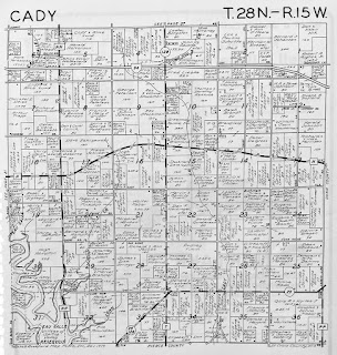
My wife and I had a small 80 acre farm in Cady township. We were in Section 18. About 45 acres were made up of arable or grassland. We also had around 35 acres of hardwoods. We had an old barn and had a few beef steers and a flock of over 50 sheep. We did not have dairy cows. We also made some babies. If you look in the photo of Cady township and look for Section 18 (to the left), you can see the location of our farm.

After 8 years, there was a divorce and my name is no longer shown on Section 18 in the current plat book. (But at least it's on the record... ) Nor have I worked in the Dairy Industry for nearly 40 years. The dairy plant in Baldwin was closed in 1990 and torn down about 20 years later. Still, I've continued to live in St. Croix County, near Baldwin, and still travel the same roads and visit farms and see the same fields and woods. I still know many people from this rural community Over these last 4+ decades, Besides the personal connections, I've continued to accumulate additional knowledge of the county, it's geography and history and it's changing personality.
St. Croix County became the fastest growing county in Wisconsin over the last 25 years. When I first came to the county in 1977, the population was approximately 36,000. Now, it is well over 95,000! This growth came because of the expansion of the Minneapolis-St.Paul Metro, coming towards Wisconsin. The heavier growth occurred in the western half of the county. The limiting factor has been the commuting time. In the mornings, people get in their cars and drive across the St. Croix River and into Minnesota. The number of individual dairy farms has plummeted. I suspect we have nearly as many dairy cows in the county as back when I was in agriculture. But the farms are typically 8-10 times the size and have become incredibly mechanized. In few cases to I consider these operations farms. More like industrial operations!


We've also had over 30 Amish families move into the area over the last 12 years. They've all settled in the eastern half of the county, away from the busier western half of the county. Wisconsin has one of the larger populations of Amish in the midwest with over 12,000 people. These local folks have taken over a number of the farms that I used to visit in the 1970s and 1980s. Sometimes they've used the older buildings. But they also have built newer barns that are fresher and more suitable to horse powered operations. This change has been a pleasant and interesting contrast to the large 400-1000 cow dairy operations. I'm happy that the Amish folks are here. They are always friendly and give a neighborly wave when I pass in my pickup truck or am riding on my bicycle. I always wave back!
Besides the Amish, we have also had a smattering of Hmong Truck Farms sprout up in the areas. The Hmong keep a lower profile and are not as conspicuous as the Amish. But I still see them out on several acreages, growing vegetables that they take into the Twin Cities in Minnesota to sell at "Farmers Markets".
 |
St. Croix County in 1840
Before Minnesota or Wisconsin
Were States |
St. Croix Was the Earliest County in the Region. The County was, at one time, much
larger. This was before the states of Wisconsin and Minnesota were
established, St. Croix County was already in existence and part of what was called "Michigan Territory". It covered
much of what is now western Wisconsin and much of Northern Minnesota.
After Wisconsin was established in 1848, St. Croix County was reduced and
took on it's current shape within the new state. It was bounded on the north by Polk County, on the south by Pierce and on the east by Dunn. To the West was the St. Croix River, which was the border with the new state of Minnesota.
Prior to the state being established The
surveyor's came thru this neighborhood in 1847 and marked out the
townships and sections. Digitalized images of the notes and maps of
the surveyors are on line at the University of Wisconsin. (Link and Image). These men would walk
across the prairies, sloughs, forests and get over the rivers and
around the lakes and swamps, using their chains, transits and stakes,
marking out and recording the land and it's contours and qualities.
This was done so that the land could be inventoried prior to
eventual sale to homesteaders, lumberman, railroads and speculators.
 |
Original Base Lines and Meridians
Subsequent Surveys Worked Off Of These |
Surveyors worked off Earlier Established Base and Range Lines. Using trigonometry and a standardized “Gunter”
chain, along with a compass, they would sight their transits and mark
off the rods, furlongs and miles, driving marker stakes into the ground periodically. Also they would be taking notes as they went along
with careful calculations. They would have to constantly check and
double-check their numbers so to make sure that their line of
travel stayed true. I can imagine them traveling, with a hardy wagon
pulled by a team of horses. Certainly they traveled with a least one
or perhaps several assistants. These Surveyors were Contractors who were paid by the Federal Government. They had to conform to the government's strict standards on the work they submitted. Otherwise they would not be paid. So they were careful! The surveyors for Western Wisconsin had to submit their completed notebooks and maps to the Federal Land Office in what is now Stillwater, Minnesota, up river from Hudson Wisconsin.
It should be kept in mind that originally, the Federal Government raised much of it's revenue from the sale of land. And so the Public Land Survey System (PLSS) was important as a mechanism for bringing in the money that the government needed to function. A good history of the PLSS is here: https://en.wikipedia.org/wiki/Public_Land_Survey_System
 |
St. Croix County 1897 Platbook Face Page
(Showing the 21 Townships) |
The County Seat of St. Croix is Hudson, on western edge of the county along the St. Croix River. More typically, the county seat (which is essentially the "Capital" of the county) was located near the center. But since in pioneer times, people originally came via the rivers or lakes, in the case of St. Croix County, the development started on the western edge and only gradually moved eastward into the interior. Originally, when people wanted to head east, towards Menomonie or Eau Claire, they either walked, rode a horse or horse-drawn wagon or they often took a stage coach.
Our farm, in Cady Township, fronted County N.
This was the Old Stagecoach Road to Menomonie. The stagecoach trip from Hudson to Menomonie was an overnight journey. It was not an express and followed a dirt trail, going over low, wet spots of over small rivers. The stage usually stopped for the night on the edge of
Eau Galle and
Cady Townships and travelers stayed at an Inn along the
Eau Galle River. The little town where the inn and stagecoach stop was located was called
Brookville (now long gone). Our farm was about half a mile east and up the hill from the river and the town.
When, after the Civil War, the Railroad was Established from St. Paul to Chicago, development penetrated faster and more intensively thru the interiors of the Wisconsin. St Croix, Pierce, Dunn and Polk counties had prairies, wetlands and woods. The further east you went, the more heavily forested it was. The lumbering industry was active here thru much of the later 1800s. Lumberjacks cut down the big trees and logs were floated down rivers in the spring; later they were hauled by sleds or on special logging trains.
 |
| Logjam on the St. Croix River |
Farms were established on land that originally had been forest. It took many decades to pull and dispose of the stumps. In the meantime, wheat was grown between the stumps and for a time, this country was where much of the flour came from. Many towns had water mills to grind the wheat into flour. After the price of wheat gradually dropped over the last decades of the 1800s, many of the farms in this area gradually shifted to dairy farming. From the 1890s and up until today, Dairy became the major focus of Wisconsin Agriculture including in St. Croix County.
After the stage coaches and railroads, the state and national highways were established. In the 1920s and 1930s, the main state highway between St. Paul Minnesota and Chicago was State Highway 12. And then, in the late 1960s, Interstate 94 was laid out and constructed and now there's a constant flow of traffic between Minnesota and Illinois that goes thru St. Croix County.
Local Surveys of St. Croix and Western Wisconsin:
When I look back at the platbook maps of the townships and county roads, I reflect that before there was a road, the surveyors had traveled slowly along this countryside in the 1840s, carefully measuring and marking down the lines and leaving behind periodic driven stakes. A painstaking process. Those lines became the township and country roads that are seen from the air.
 |
| Transit, Chain, Compass, Axe and Stakes |
St. Croix is just one of the 72 counties in Wisconsin! In those Wisconsin Counties there are 1260 Townships. You start to think of all the counties and townships in the country and it boggles the mind! Each community with its own particular features, histories and families. So many stories to be told.... This country is a vast tapestry.
When I bicycle in the countryside, I often ponder over the county and community I am traveling thru.
I've been here in St. Croix County for 45 years and shall stay here until I die. Then I'll be buried here. I've the plot purchased in a cemetery that's nearly abandoned. I'll be buried in the old Brookville Cemetery, Lot 107. The grass grows long there most of the time. This is within a mile of where our old farm was.
 |
| Fly-Over-Land |
So when I hear someone derisively refer to Fly-Over-Land, I just look at them and smile at their ignorance. They're happily oblivious of what they pass thru or over.


